

Differences Between 905nm and 1550nm Lidar in Aerial Mapping
Introduction
Lidar (Light Detection and Ranging) technology has elevated aerial mapping beyond the limitations of photogrammetry by providing high-resolution, three-dimensional information about the Earth's surface. Among the various wavelengths used in lidar systems, 1550nm and 905nm are two prominent options, each with distinct characteristics and applications. This article explores the differences between these two wavelengths and their implications for aerial mapping.
Wavelength Characteristics
905nm Lidar
The 905nm wavelength is commonly used in commercial lidar systems, particularly in smaller sensors mounted on drone platforms and autonomous vehicles. 905nm wavelength sensors have advanced through their development as sensors for autonomous vehicles and SLAM applications. This wavelength falls within the near-infrared spectrum and is particularly effective in vegetation mapping due to its ability to penetrate foliage to some extent. Key characteristics include:
Sensitivity to Vegetation - The 905nm wavelength interacts well with chlorophyll, allowing it to capture detailed information about vegetation structure.
Lower Cost - Systems operating at 905nm are generally more affordable and accessible, making them popular for a more general range of applications from forestry to civil engineering.
Safety Regulations - This wavelength is considered safe for human exposure, which has made it suitable for widespread use without strict regulatory limitations.
1550nm Lidar
The 1550nm wavelength is typically associated with more advanced lidar systems, particularly those used in large-scale surveying and mapping projects. It offers unique advantages that make it appealing for certain applications:
Longer Range and Higher Precision - The 1550nm wavelength allows for greater distances to be emitted and received, which is particularly useful in large-area surveys. It also offers improved precision in depth measurements.
Reduced Atmospheric Interference - This wavelength is less affected by atmospheric scattering, allowing for more consistent data collection in varying weather conditions.
Eye Safety - Although 1550nm is also considered safe, it poses less risk than lower wavelengths in terms of eye exposure, leading to its adoption in applications where laser safety is a concern.
Effects on Aerial Mapping
Data Quality
The choice between 905nm and 1550nm lidar can significantly affect data quality in aerial mapping projects:
Penetration Ability - While 905nm lidar excels in applications requiring detailed vegetation mapping, 1550nm lidar offers better performance detecting infrastructure where higher precision is required.
Point Density and Accuracy - 1550nm systems can achieve higher point densities at greater distances, which is essential for applications requiring fine detail, such as infrastructure inspections or civil site design.
Reflectivity – 905nm sensors distribute their laser power through multiple channels and therefore have a weaker power source. Because of this, darker surfaces absorb laser measurements that may not return to the sensor. 1550nm sensors have an advantage in these situations.
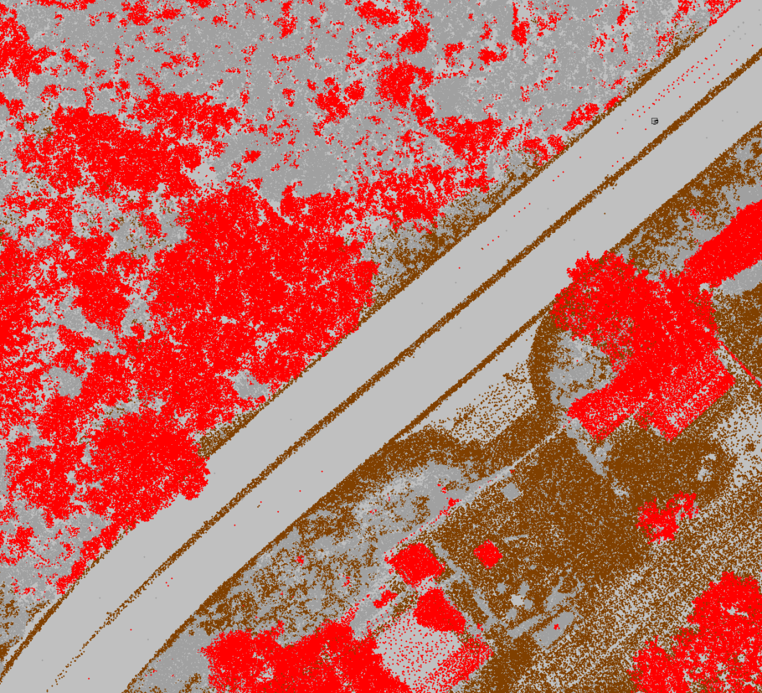
Effects of 905nm laser on asphalt as an example of an absorptive surface material.
Application Suitability
Different applications may favor one wavelength over the other:
Forestry and Agriculture - 905nm lidar is often preferred for forest inventory and agricultural assessments due to its sensitivity to vegetation.
Topographic Mapping - 1550nm lidar is more suitable for topographic mapping and large-scale land surveys, where distance and accuracy are paramount.
Infrastructure – 1550nm lidar is more suitable when mapping developed and improved areas with areas of hardscape such as asphalt and concrete. 1550nm generally are less sensitive to absorptive surfaces.
Cost and Accessibility
Cost considerations also play a crucial role in the selection of lidar systems. 905nm systems are generally more cost-effective and thus more accessible to smaller organizations and projects. In contrast, while 1550nm systems offer superior performance, they come with a higher price tag and are often reserved for larger-scale projects or specialized applications. Project types, budgetary concerns, and return on investment must be considered.
Conclusion
The choice between 1550nm and 905nm lidar systems significantly influences aerial mapping projects. While 905nm is advantageous for vegetation mapping and affordability, 1550nm provides enhanced range, accuracy, and reduced atmospheric interference. Understanding these differences allows practitioners to select the most appropriate lidar technology for their specific mapping needs, ensuring optimal results in various applications. As lidar technology continues to evolve, the importance of selecting the right wavelength, amongst many other technical characteristics, will remain a critical factor in the effectiveness of aerial mapping initiatives.